Haz clic aquí para ver la versión en español.
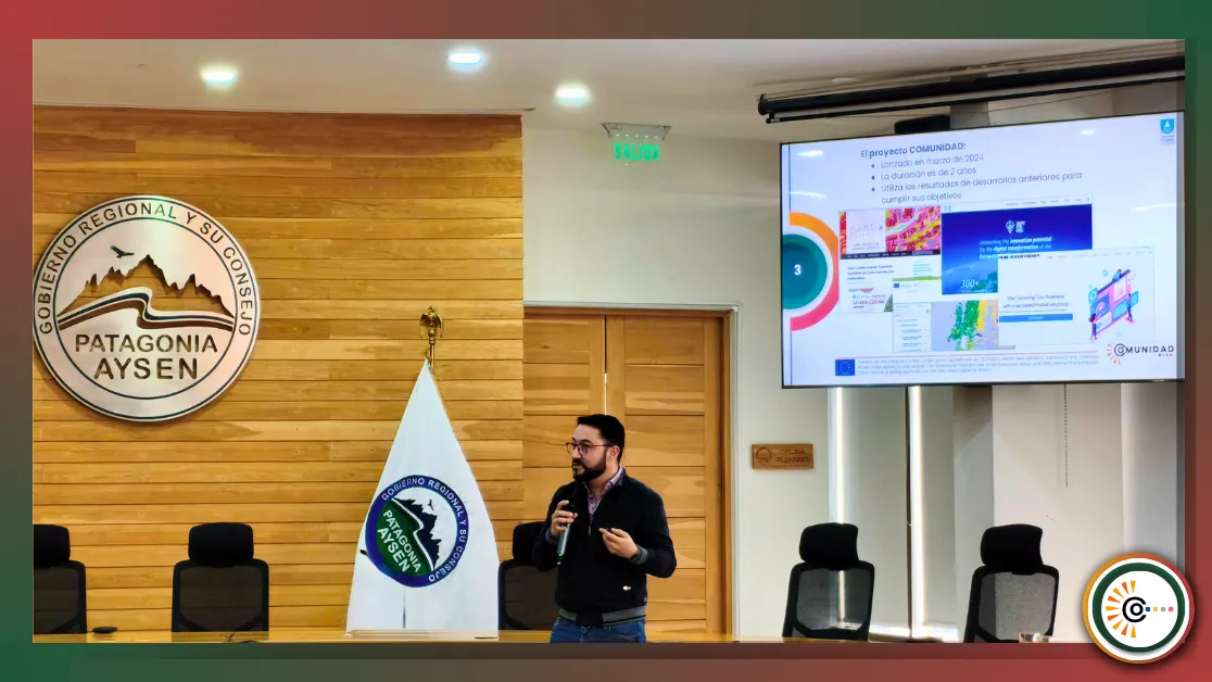
On October 15, 2025, the COMUNIDAD Project played a significant role in the 2nd Session of the Regional Geospatial Data Infrastructure (IDE) Table of Aysén, held at the Salón Ronchi of the Aysén Regional Government building. The meeting, which brought together key stakeholders from the public, private, and academic sectors, marked a milestone with the official launch of the IDE GORE Aysén Geoportal.
The session was inaugurated by authorities from the Aysén Regional Government and featured presentations from IDE Chile, which outlined the current status of the National Geospatial Information Policy.
Regional Experiences and the COMUNIDAD Vision
In the segment dedicated to "Regional experiences in geospatial information management", Dr. Johnny Valencia, Researcher of the COMUNIDAD Project and WP4 Leader (Chilean and Colombian Pilots ), was invited to present the progress of this European Union-funded initiative (Horizon-EUSPA-RIA2022-SPACE).
Dr. Valencia shared the panel with other important regional actors, such as Sebastián Fernández, GIS Analyst for the Glaciers Program at DGA/MOP , and Andrea Aguilar, Director of Sernageomin, who presented their respective institutions' platforms and strategies for territorial monitoring and data management.
In his presentation, the COMUNIDAD Project emphasized the need to apply "algorithmic territoriality." This concept underscores the importance of adapting global models and satellite data processing algorithms to the specific needs and contexts of the Patagonian territory. The goal is to improve decision-making by developing user-centered, locally validated solutions.
The use cases being developed by the project in the Aysén Region were presented, focusing on:
- Snow Cover Estimation using artificial intelligence algorithms.
- Updating the Silvo-agricultural (Forestry and Agriculture) Land Use layer.
- Forest Fire Management and Monitoring in remote areas.
A Strategic Alliance for Data Governance
Participating in the IDE Aysén Table is strategic for the COMUNIDAD Project, as this coordination space aligns directly with the project's objectives of defining governance models and fostering co-creation.
The new regional Geoportal, along with the "Geonode Workshop" held on October 16, opens a fundamental channel for bidirectional collaboration. The COMUNIDAD Project can contribute its developments, interoperable data, and APIs to the regional platform, and in turn, receive feedback from local services and stakeholders to validate its results.
We extend our deep gratitude to the Aysén Regional Government, the coordination of the IDE Aysén Table, and IDE Chile for fostering this collaborative ecosystem. This initiative reinforces the commitment to continue building an active community around the use of geospatial data for the sustainable development of Patagonia.
Stay tuned for insights from other consortium members and follow us on social media for regular updates on the COMUNIDAD project's outcome.
Click here to view the English version.
Proyecto COMUNIDAD destaca la "Territorialidad Algorítmica" en la 2ª Sesión de la Mesa IDE Aysén y el lanzamiento del Geoportal Regional
Fecha: 28 de octubre de 2025
El pasado 15 de octubre de 2025, el Proyecto COMUNIDAD tuvo una destacada participación en la 2ª Sesión de la Mesa Regional de Infraestructura de Datos Geoespaciales (IDE) Aysén , celebrada en el Salón Ronchi del Gobierno Regional de Aysén. El encuentro, que congregó a actores clave del sector público, privado y de la academia, marcó un hito con el lanzamiento oficial del Geoportal IDE GORE Aysén.
La sesión fue inaugurada por autoridades del Gobierno Regional de Aysén y contó con presentaciones de IDE Chile, quienes expusieron el estado actual de la Política Nacional de Información Geoespacial.
Experiencias Regionales y la Visión de COMUNIDAD
En el bloque dedicado a "Experiencias regionales en la gestión de Información geoespacial", el Dr. Johnny Valencia, investigador del Proyecto COMUNIDAD y líder del WP4 (Pilotos en Chile y Colombia), fue invitado a exponer los avances de esta iniciativa financiada por la Unión Europea (Horizon-EUSPA-RIA2022-SPACE).
El Dr. Valencia compartió panel con otros importantes actores regionales, como Sebastián Fernández, Analista SIG del Programa Glaciares de la DGA/MOP , y Andrea Aguilar, Directora de Sernageomin, quienes presentaron las plataformas y estrategias de sus respectivas instituciones para el monitoreo territorial y la gestión de datos.
En su presentación, el Proyecto COMUNIDAD relevó la necesidad de aplicar una "territorialidad algorítmica". Este concepto subraya la importancia de adaptar los modelos globales y los algoritmos de procesamiento de datos satelitales a las necesidades y contextos específicos del territorio patagónico. El objetivo es mejorar la toma de decisiones desarrollando soluciones centradas en el usuario y validadas localmente.
Se presentaron los casos de uso que el proyecto desarrolla en la Región de Aysén, enfocados en:
- Estimación de Cobertura de Nieve mediante algoritmos de inteligencia artificial.
- Actualización de la capa de Usos de Suelo Silvoagropecuario.
- Gestión y Monitoreo de Incendios Forestales en zonas remotas.
Una Alianza Estratégica para la Gobernanza de Datos
La participación en la Mesa IDE Aysén es estratégica para el Proyecto COMUNIDAD, ya que este espacio de articulación se alinea directamente con los objetivos del proyecto de definir modelos de gobernanza y fomentar la co-creación.
El nuevo Geoportal regional, junto con el "Workshop Geonodo" realizado el 16 de octubre, abre un canal de colaboración bidireccional fundamental. El Proyecto COMUNIDAD puede aportar sus desarrollos, datos interoperables y APIs a la plataforma regional, y, a su vez, nutrirse de la retroalimentación de los servicios y actores locales para validar sus resultados.
Agradecemos profundamente al Gobierno Regional de Aysén, a la coordinación de la Mesa IDE Aysén y a IDE Chile por fomentar este ecosistema de colaboración. Esta iniciativa refuerza el compromiso de seguir construyendo una comunidad activa en torno al uso de datos geoespaciales para el desarrollo sostenible de la Patagonia.
Mantente atento a las perspectivas de otros miembros del consorcio y síguenos en nuestras redes sociales para recibir actualizaciones periódicas sobre los resultados del proyecto COMUNIDAD.
Existing Comments